
Disaster Relief Simulation
The research project ‘Disaster Relief Simulation’ is dealing with the issue of resource allocation, information asymmetry and collaborative planning at the site of emergencies. The focus is to develop optimal decision-making strategies using a theoretic simulation approach. This simulation allows to derive and evaluate different communication and management strategies. The results should help to set up and calibrate an information system which is tracking the resources on a disaster site and should provide relevant information to the different actors. Therefore the system provides an algorithmic-filtered information stream for the officers and decision makers, allowing them to make optimal just-in-time decisions. A real-world mobile system has been developed, calibrated and calibrated by this study.
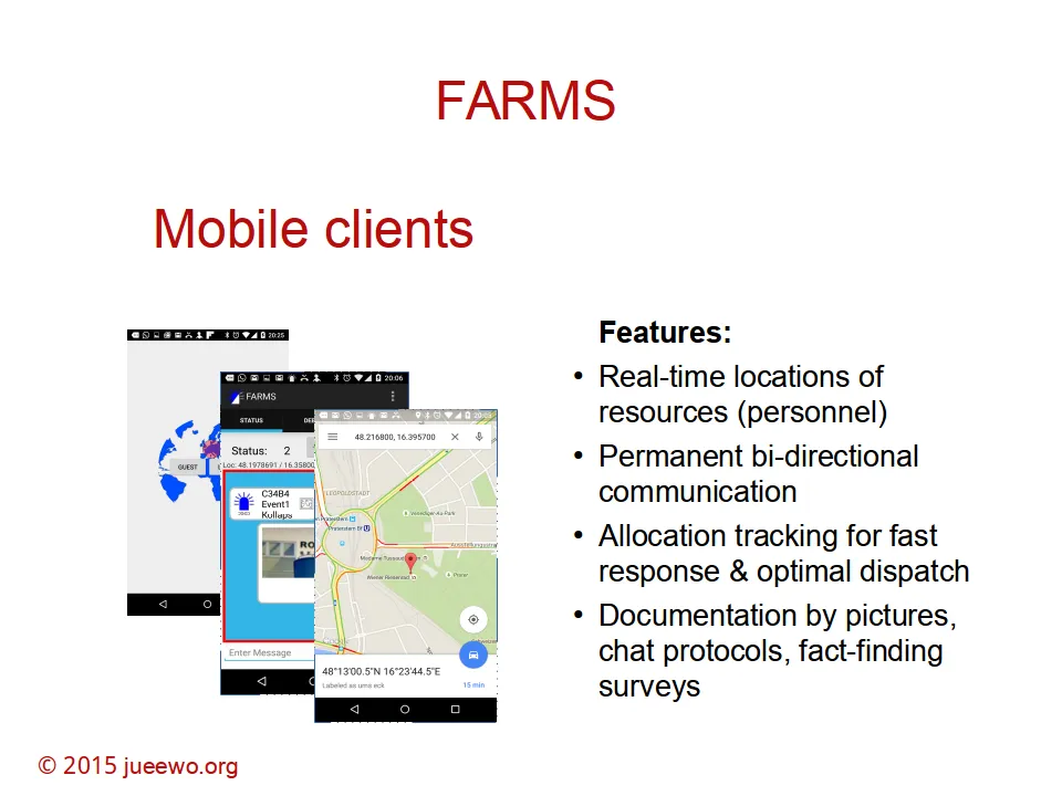
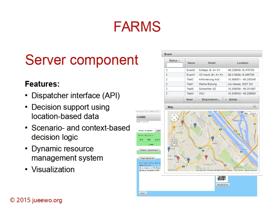
Implementation: “First Action Resource Management System” (FARMS)
The concepts of the research project have been implemented and tested with an NGO in Austria. The prototypic implementation is called FARMS and stands for “First Action Resource Management System”. It is expressing the purpose of managing and guiding resources in disaster release scenarios.
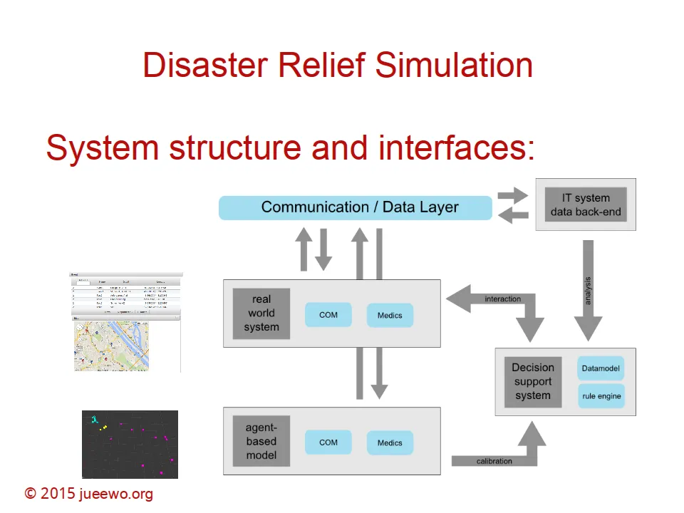
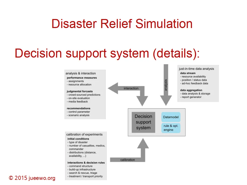
System architecture / Implementation
Publications
Article:
-
Woeckl: Location-based resource management and collaborative planning in the field of disaster relief operations. POMS Singapore (2014)
-
Woeckl: Just-in-time classification of location-based data to optimize assignment and routing decisions in supply chains. POMS Singapore (2014)
Abstracts:
Location-based resource management and collaborative planning in the field of disaster relief operations
In the field of an disaster relief operation its critical to gather and distribute knowledge about the actual status of the operation – which is highly dynamic and therefore changing over time. Here we introduce an advanced planning & decision support system to collaboratively capture and share information within a decentralized and dynamic structure. Dynamic algorithms are used to aggregate the information and to redistribute the optimization results and strategic decisions supported by the aggregated data. The system is able to form an ad-hoc network, using mobile phones as location-based data-collection clients and mobile servers as a data back-end.
Just-in-time classification of location-based data to optimize assignment and routing decisions in supply chains
Based on location-based transaction data (e.g. pictures, routes, descriptions, status reports) captured by a decision support system in the field of disaster relief and supply chains management in general, an optimal assignment of resources to events and an optimal routing should be derived. Big data algorithms are applied to classify the actual situational data and to calibrate the decision rules for the required just-in-time assignment and routing decision of resources. The unstructured high-dimensional input data are enriched by expert knowledge forming a judgmental forecast system, which is used to control the effect of the decisions on supply chain performance measures.
Presentation:
-
- Wiener Neustädter Notfallkongress “Schnittstellen”, 28.8.2015, Arena Nova, Wiener Neustadt, Austria; www.notfallkongress.at